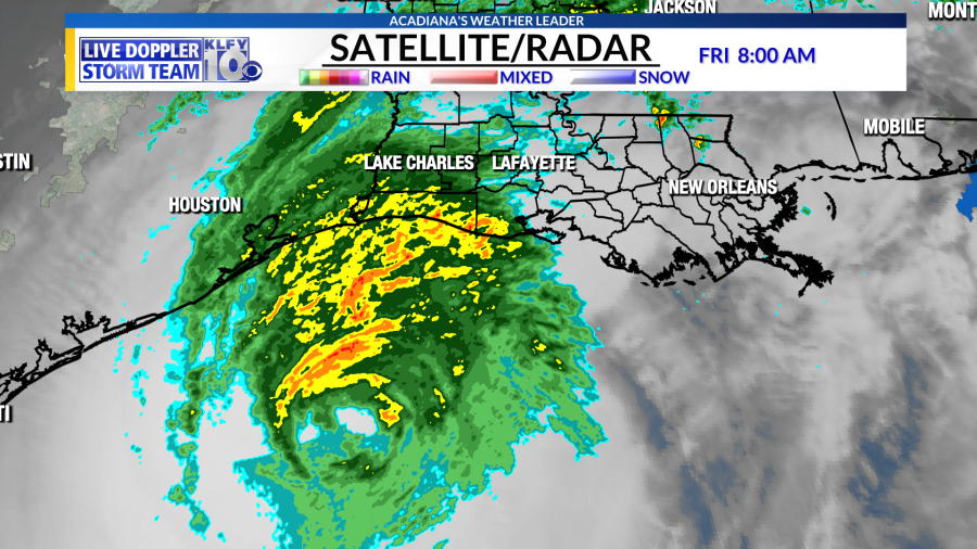
6 a.m. (10/10/20) Temperatures currently in the 60’s as Satellite shows Tropical Storm Delta continuing to work northward across the northern parts of the state.
The live doppler 10 shows the storm working in through the past 12 hours.
Here’s the latest track on delta which is now weakening as a tropical storm—it will continue to progress northward and turn into a remnant low over the eastern u.s.
Rainfall totals across the area were in the 5-10 inch range with the higher totals across western and northern portions of Acadiana.
Temperatures today will climb into the 80’s so yes it will be hot for those without power but at least it’s not in the 90’s.
Maximum wind gusts started near the coast and worked northward through the evening–most of acadiana received 70-90 mph wind gusts with a few 100 mph wind gusts possibly across Acadia, western Vermilion and Jeff Davis parishes.
Futuretrack shows partly cloudy skies later today and mostly sunny skies Sunday.
Maximum wind gusts today in the 15-20 mph range so hopefully winds will die down to allow crews to get out here and begin the cleanup and the restoration of power.the good news is we may try to get a front in here by the middle parts of next week.
Forecast for Saturday, clearing clouds–warm.
Seven day forecast shows nice weather after this all the way through next week.
10 p.m. (10/09/20) Hurricane Delta’s wind speeds as the storm moves farther inland into Louisiana. Maximum sustained winds are now 75 mph.
ORIGINAL: Hurricane Delta continues to weaken with wind speeds at 105 mph. The current movement is to the north-north-northeast at 14 mph.
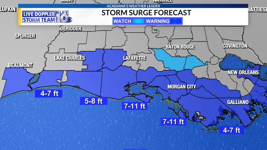
Delta is still expected to be a powerful category 1/2 hurricane at landfall with a broad wind field. Due to this, most of Acadiana will see potentially damaging wind gusts and surge will be a major issue across coastal Vermilion, Iberia, and St. Mary.
Futuretrack has outer rainbands beginning to work ashore through the early afternoon hours. These bands could contain tropical-storm-force wind gusts of 40-50 mph. We’ll also have to watch for the possibility of heavy rainfall and high rainfall rates in some of these storms.
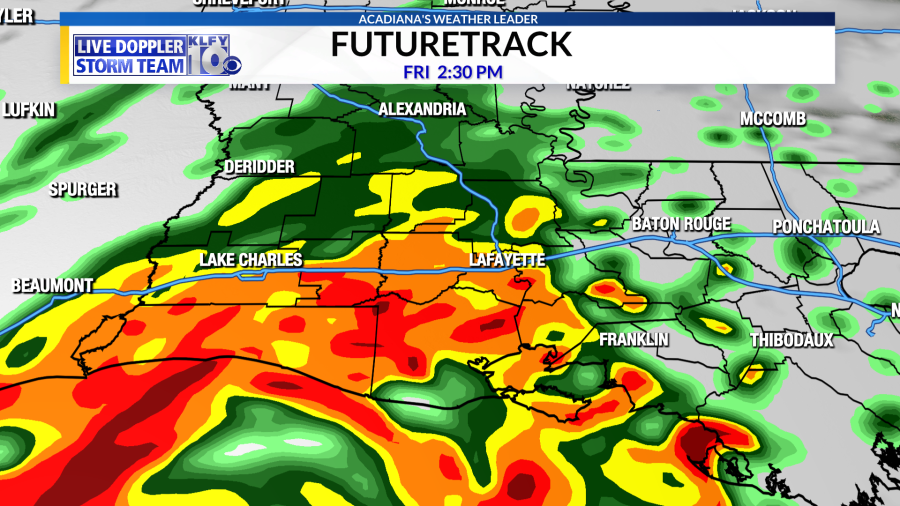
Later in the evening, the eye will move ashore. The strongest storms, according to the RPM and other high-resolution models, will be on the north and northeastern side of the eyewall. These will be the storms capable of producing the strongest wind gusts.
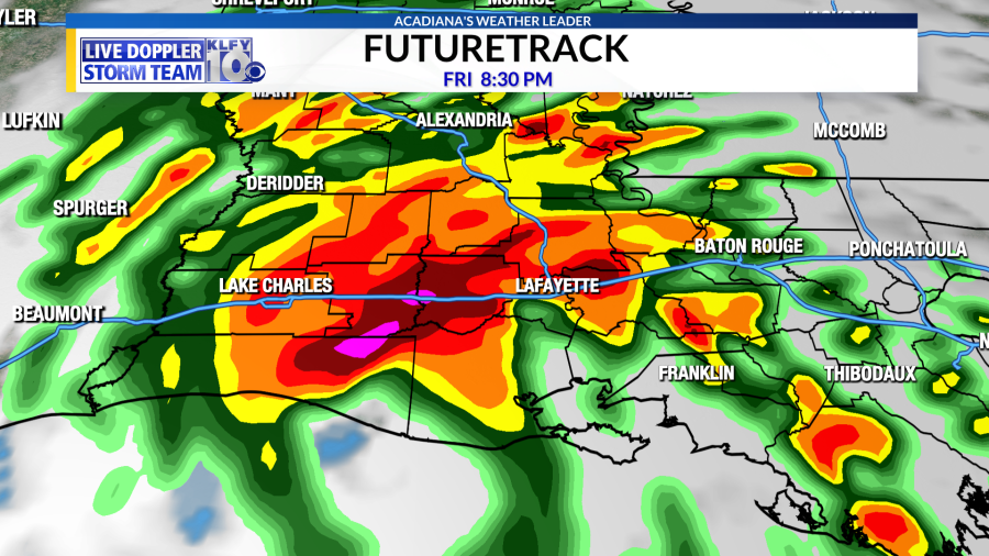
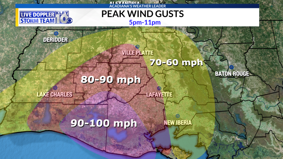
Since the hurricane will be weakening as it progresses inland, the highest wind gusts (90-100 mph) will be possible near and just east of the landfall location, namely eastern Cameron, western Vermilion, and Jeff Davis parishes. As the hurricane progresses northward, 80-90 mph wind gusts could be possible in the general vicinity of the track, including Jeff Davis, Acadia, western Lafayette, eastern Vermilion, and possibly even southern Evangeline. Elsewhere, wind gusts of 60-70 mph will be possible across northern Evangeline, St. Landry, St. Martin, Iberia, and St. Mary. Overall, I feel winds could be slightly higher than what was observed with Laura in most Acadiana locations, but especially in Acadia, Cameron, and Vermilion parishes.
These winds will be strong enough to knock down large, vulnerable trees and also power lines. This will likely lead to widespread power outages, which could take a few days to be restored. If you are in a mobile home, or a home surrounded by large trees, now is the time to go stay with a friend of family member. Otherwise, stay hunkered down, away from doors and windows, and you should be able to ride out this system!
Some heavier rain/flash flooding could be possible, but overall flooding won’t be the biggest concern. The storm will be progressing through the area rather quickly, which could hopefully limit rainfall totals. Dry air wrapping into the circulation could also aid us, choking off the southern side of the circulation.

Finally, after the storm is passed make sure to be safe with generators. Do not run generators in enclosed areas and make sure to power it off when re-fueling. Read the manual that comes with the generator to ensure proper use. Do not travel immediately after the storm as trees, power lines, and even flood waters could be obstructing roadways. Keep in tuned to KLFY and KLFY.com throughout the day for continuous updates.


